Ground Investigation Adjacent to a Reservoir
Weston Turville reservoir was constructed towards the end of the 18th Century to store water for the Grand Union Canal. Today, the reservoir is an amenity lake with public access for recreation, fishing and sailing.
The purpose of the ground investigation was to investigate the composition of the subsidiary embankment dam (including the identification of a clay core, if present) and to obtain samples for geotechnical testing to assess the erodibility of material.
Mott Macdonald were engaged by the Canal and River Trust to fulfil the role as the Investigation Supervisor on the project to specify the ground investigation scope and complete the subsequent design. Geotechnical Engineering Ltd were appointed as the Principal Contractor for carrying out a range of hand excavated trial pits, boreholes, soakaway tests and soil/water samples.
The project was undertaken within the boundaries of a designated Site of Special Scientific Interest (SSSI), an area recognised for its unique ecological importance. The majority of the reservoir site sits on Cretaceous-aged Upper Greensand and Gault Clay.
The ground investigation was conducted in two phases. The first phase focused on positions situated on the embankment, while the second phase necessitated approval of a Flood Risk Activity Permit (FRAP) by the Environmental Agency to prevent the risk of flooding.
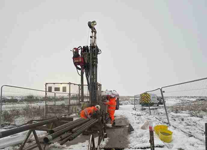
A total of 7 hand-held window sampler holes were drilled to their refusal depth, reaching up to 4.75m depth. 4 of these were positioned along the crest of the subsidiary embankment, while another 4 were located at the downstream shoulder edge of the crest. Due to the slope on-
site, which needed to be used for accessing the embankment crest, a load-bearing assessment was required before any vehicles could be manoeuvred. As a result, hand-held window sampling equipment was chosen as the most suitable option for this project to negate the need for vehicular movements.
Various hand shear vane tests were undertaken within the clay material encountered in the uppermost 0.50m of each borehole.

Following the Project Engineer’s instructions, these positions were backfilled using a combination of grout and cement. To ensure the backfill material was adequately settled, a concrete poker was employed.
5 hand excavated trial pits were carried out on the subsidiary embankment, each reaching a depth of 1.20m. Additionally, 2 trial pits were excavated by hand in the northwestern corner of the bywash channel stream bed, also to a depth of 1.20m. These were backfilled with ultra-set cement to ensure rapid solidification and to prevent any risk of cross-contamination in the water.
The purpose of these positions was to detail the soil-type that made up the channel stream bed in order to understand the construction composition. Small scale soakaway tests were also carried out within each pit.
The positions falling under the FRAP requirements necessitated the installation of a micro-dam around the work
area using sandbags to stop water from flowing into the reservoir. For positions situated very close to the reservoir, a secondary dam was constructed, incorporating a submersible pump to divert the water. The pump was placed on a plant nappy positioned atop the sandbags.
Raw surface water samples were collected from the reservoir for the purpose of Langelier Saturation Index and Ryznar Index laboratory testing. These indexes are a measure used to evaluate the balance of water chemistry, specifically to predict the scaling or corrosive tendencies of water. These samples were tested for their temperature using a thermometer immediately on sampling and again once the sample reached the laboratory. Those approaching the reservoir to collect the samples wore a life jacket as an essential safety precaution.
CEMAR (Contract Event Management and Reporting) was utilised on this project as a tool to enhance the management of the contract. This software supports project managers, contractors, and their teams by advancing collaboration, ensuring adherence to regulations, mitigating risks, and simplifying contract administration processes.
The project was successfully delivered as a result of thorough planning, elevated attention to environmental factors, and strict adherence to safety protocols throughout its execution. These proactive measures ensured that all activities were carried out responsibly, efficiently, and in full alignment with both operational and regulatory expectations.
Explore similar projects
West of Orkney Windfarm

Cropthorne STW Phase 2

Grwyne Fawr Reservoir – Dam Stability Study

The Thorpe Marsh Green Energy Hub: Battery Energy Storage System

50 Fenchurch Street Ground Investigation

Elan Valley Aqueduct – Bath Coppice Tunnels
-
Centurion House, Olympus Park
Quedgeley, Gloucester GL2 4NF - 01452 527 743
-
Jactin House, 24 Hood Street
Ancoats, Manchester, M4 6WX - 0161 327 3933
- geotech@geoeng.co.uk
- geospatial@geoeng.co.uk