Environmental Permitting Ground Investigation
The ground investigation (GI) took place on an area of ground where Pulverised Fly Ash (PFA) from the former Thorpe Marsh Power Station had been stockpiled. The majority of the PFA on site has been tipped in a raised horseshoe formation up to 20m high surrounding a flat area of largely waterlogged land. The original plan for the site had been to fill the horseshoe with PFA, but the Power Station ceased operations early and the PFA stockpile was never completed to the anticipated extent.
The site is located to the west side of the former Thorpe Marsh Power Station (active between 1963 and 1994), approximately 6 km north of Doncaster town centre. Thorpe Marsh Drain runs through the middle of the site (in through the northern boundary and out of the southern boundary, prior to running along the southern and south-western site boundaries). The western part of the site (west of Thorpe Marsh Drain) comprises the former Thorpe Marsh (coal-fired) Power Plant Pulverised Fuel Ash (PFA) disposal area. The east of the site comprises areas previously occupied by infrastructure associated with the Thorpe Marsh Power Station and a road (Marsh Lane).
The surrounding land use comprises predominantly agricultural land, including the existing Network Rail freight rail line, and the Thorpe Marsh Nature Reserve to the west.
The proposed development on site includes earthworks, comprising the excavation and replacement (re-compaction) of material within the PFA stockpile area to provide a level development area. It also includes the possible extension of the development area to the south to allow for future additional battery storage and infrastructure; Construction of foundations to support the proposed battery units and infrastructure; Construction of foundations to support a substation; Possible development to the north-east of the former coal stocking yard to allow siting of battery array and substation; Routing of cables to the substations and possible reinstatement of former railway sidings to the north of the PFA stockpile.

Geotechnical Engineering Limited (GEL) were appointed by the client, on recommendation from the Investigation Supervisor as a specialist contractor capable of running and delivering this complex project to a high technical standard and within a demanding timeframe.
The site’s historical use had resulted in a range of legacy challenges that needed to be addressed to achieve the project objectives. Extensive areas of hardstanding and subsurface structures were encountered, including thick surface concrete and underground concrete tunnels with voids exceeding 3.0 metres. These features required careful planning and management to ensure safe and effective delivery of the investigation.
Site access was strictly regulated by the site management team. Operations were conducted under a Transfer of Control of Premises (ToCoP) agreement, ensuring clear responsibility for site safety, coordination, and compliance throughout the investigation.
In addition to the main basement works, an additional borehole was requested inside the All Hallow’s Staining church tower to confirm the ground conditions for underpinning and stabilisation works. Given the exceptional national significance of the Grade I listed church, every stage of the borehole construction was planned and executed with conservation-led methodology, including precise skilled assembly of the rig in order to complete the borehole in a safe and efficient manner. The enabling works went far beyond basic protection measures and were designed to ensure that no part of the historic fabric, whether structural, decorative, or archaeological, was exposed to risk.
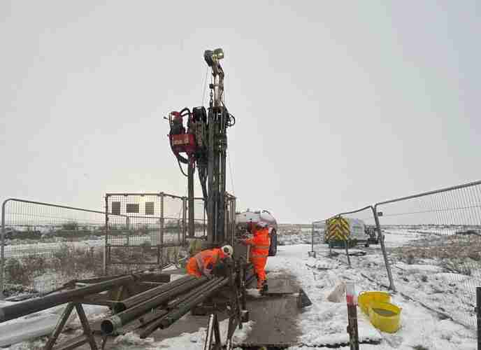
A total of 22 boreholes were constructed across the site using cable percussion drilling techniques, with depths ranging from 3m to 40m depending on ground conditions and investigation requirements. These boreholes provided access to deeper strata for sampling, geotechnical logging, and in-situ testing. Clean drilling methods were essential to safeguard the integrity of the underlying formation. In addition, 27 trial pits and inspection trenches were excavated using mechanical plant to expose shallow ground conditions and subsurface structures. These excavations enabled direct visual inspection and facilitated the collection of representative samples for laboratory analysis. Material from nine existing stockpiles was also sampled to assess composition, potential contamination, and suitability for reuse or disposal.

Fig 1: Excavator set up on trial pit position
To mitigate the risk of artesian conditions, borehole completion depths were carefully revised in collaboration with the Investigation Supervisor. This approach ensured that the confined aquifer strata were avoided, while still allowing the collection of all necessary data to meet the investigation objectives.
The saturated ground conditions, enclosed by a surrounding horseshoe of elevated terrain, created considerable difficulties in transporting plant and equipment across the site. These access challenges were further intensified by a spell of particularly wet weather during the investigation period, compounding logistical constraints and requiring careful planning to maintain progress and safety.
The confirmation of suspected contamination locations in certain areas of the site necessitated the immediate implementation of mitigation measures to protect health and safety. These actions included continuous on-site monitoring of airborne fibres, establishment of exclusion zones to restrict access, and the provision and enforcement of appropriate personal protective equipment (PPE) and respiratory protective equipment (RPE) for all personnel operating within affected zones.
Effective collaboration and ongoing communication between all stakeholders and site users at management and operational levels both before and throughout the investigation contributed to the smooth delivery of this project. This proactive engagement helped maintain strong working relationships and ensured alignment on safety, logistics, and project objectives.
Explore similar projects
West of Orkney Windfarm

Cropthorne STW Phase 2

Grwyne Fawr Reservoir – Dam Stability Study
The Thorpe Marsh Green Energy Hub: Battery Energy Storage System

50 Fenchurch Street Ground Investigation

Elan Valley Aqueduct – Bath Coppice Tunnels
-
Centurion House, Olympus Park
Quedgeley, Gloucester GL2 4NF - 01452 527 743
-
Jactin House, 24 Hood Street
Ancoats, Manchester, M4 6WX - 0161 327 3933
- geotech@geoeng.co.uk
- geospatial@geoeng.co.uk