Site Investigation Works Adjacent to Sharpness Canal
Frampton Embankment is a principal embankment situated on the towpath side of the Gloucester and Sharpness Canal, located approximately 750m southwest of Frampton-on-Severn in Gloucestershire. The hard bank protection comprises concrete piles with waling, which are currently in fair condition, but localised sections are beginning to rotate forwards. A drainage ditch is situated at the toe of the structure, causing the lower slope and toe to be oversteep.
The purpose of the ground investigation was to investigate the embankment construction materials and the underlying natural foundation strata and obtain samples for geotechnical and geo-environmental testing. The results of the investigation will be used to determine the ground conditions and characteristic geotechnical parameters to inform a slope stability analysis and assist with the design of the structural sheet piling works.
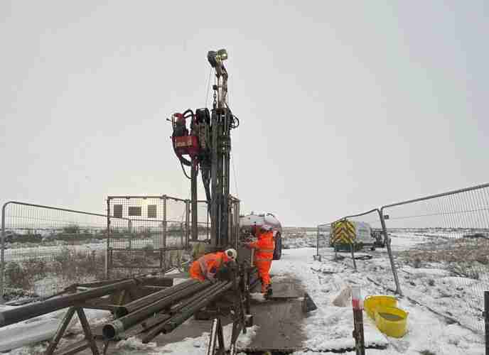
The Canal and River Trust acted as Consultant Engineer, setting the ground investigation scope and completing design works. Geotechnical Engineering Ltd, appointed as Principal Contractor, carried out dynamic boreholes, dynamic probe tests, and inspection pits to assess embankment materials and foundation strata.

The window sampling rig was required to be tracked over a considerable distance of just over 1.5km, resulting in a minor delay to the commencement of the ground investigation. Despite the setback, operations proceeded as planned once the equipment was fully mobilised to the designated location.
Edge protection was established to safeguard all staff working near the canal, with a mandatory exclusion zone of at least 2m being maintained from the water’s edge. All operatives were equipped with life jackets, and a life buoy was positioned on the rig side to provide immediate response capability in the event of an emergency.
7 window sample boreholes were drilled to depths of up to 8m to assess the lateral extent and composition of embankment materials, while also determining the depth and makeup of the underlying foundation strata. To enhance these findings, 7 dynamic probe tests were conducted to 10m, either through or adjacent to the boreholes, enhancing the subsurface profiling and refining geotechnical interpretation.
5 hand-dug inspection pits, each reaching a maximum depth of 1.20m, were excavated to identify the position, depth, and overall dimensions of the embankment’s clay core. These pits also facilitated infiltration testing, providing valuable data on the subsurface permeability and supporting assessments of the embankment’s structural integrity and drainage characteristics.
Site activities were carefully managed to accommodate ongoing public access, with the pathway being kept open throughout the works. Operations were temporarily halted whenever a member of the public entered or neared the active area, ensuring safety and respectful interaction. Upon completion, the footpath was reinstated in line with rights of way and local authority standards, closely matching its original condition to preserve safe, uninterrupted use.
CEMAR (Contract Event Management and Reporting) played a key role in the successful delivery of the project by streamlining contract management and strengthening team coordination. Its use enhanced collaboration between stakeholders, ensured regulatory compliance, and reduced administrative complexity, all contributing to efficient risk control and smoother project execution.
Explore similar projects
West of Orkney Windfarm

Cropthorne STW Phase 2

Grwyne Fawr Reservoir – Dam Stability Study

The Thorpe Marsh Green Energy Hub: Battery Energy Storage System

50 Fenchurch Street Ground Investigation

Elan Valley Aqueduct – Bath Coppice Tunnels
-
Centurion House, Olympus Park
Quedgeley, Gloucester GL2 4NF - 01452 527 743
-
Jactin House, 24 Hood Street
Ancoats, Manchester, M4 6WX - 0161 327 3933
- geotech@geoeng.co.uk
- geospatial@geoeng.co.uk