Ground investigation on a Sewage Treatment Works
It is proposed to construct a sheet piled retaining wall, new inlet works, a sludge storage tank, two primary settlement tanks, three bio filters, two humus tanks and access roads all connected to the Cropthorne Heath Sewage Treatment Works (STW).
Severn Trent Water fulfilled the role as the Consultant Engineer on the project to specify the ground investigation scope and complete the subsequent design. Geotechnical Engineering Ltd were appointed as the Principal Contractor to undertake a programme of cable percussive and rotary drilling works for sample recovery and installation of gas and
groundwater monitoring equipment. Windowless sampling was also required. Hand shear vanes were carried out in suitable material to provide accurate results of shear strength.

The geology includes alluvium over the Allstone Member (sand and gravels), underlain by Charmouth Mudstone. Made Ground deposits were present as a result of the initial construction of the STW.
All supervisors and operators working on this project required successful completion of the National Water Hygiene Scheme. This scheme provides workers with the required knowledge and awareness of good water hygiene practices when undertaking excavations nearby any associated water courses.
Before any excavations began, a PAS128 Utility Avoidance survey was conducted at the site. This standard survey for underground utility detection, verification, and location ensures precise and consistent data collection regarding the position of underground utilities. Electromagnetic techniques, Ground Penetrating Radar (GPR), and visual inspections were utilised to detect and map the underground services during this survey.

Fig 1. Ground markings highlighting underground utilities detected following the PAS128 utility avoidance survey
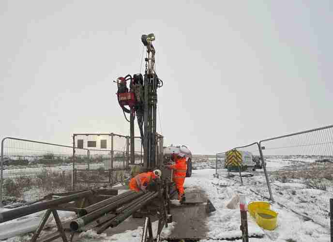
6 borehole positions were completed up to a depth of 30m on a slope with an incline of up to 10°, using a light cable tool (shell and auger) rig with 200mm tools and casing. Initially, the slope was benched and levelled with a mini loader, ensuring the cable tool rig could be safely set up at each position. When shell and auger sampling could no longer proceed, rotary core drilling techniques were employed to continue the boreholes. The transition from the cable tool rig to the rotary coring rig required extra operational care and precision to ensure the rig was safely and vertically aligned before drilling resumed. Monitoring wells were installed at each borehole position.
To manage the disposal of excess drilling flush, the flush was stored in industrial bulk containers (IBCs) before the mini loader transported them to the site compound. Further arrangements were made for its off-site removal and disposal.
Falling head permeability tests were carried out in 2 borehole positions by topping up the borehole with clean water. Permeability tests are used to measure the ability of a material to allow fluids to pass through it, with the time in which it takes the water level to fall being recorded.
The installations, along with two historic borehole locations were monitored for gas flow and then tested for methane, carbon dioxide, oxygen, hydrogen sulphide, and carbon monoxide using a Gas Data GFM 435 gas analyser. Prior to water sampling, the water monitoring standpipes were developed by pumping and then purged until at least three well volumes of water had been removed. There were also four falling head permeability tests carried out within the monitoring wells.

Fig 2. One borehole under construction and another at completion.
8 boreholes were formed using a window sampling rig and were completed up to 5m depth.
A single dynamic probe hole position was also undertaken using the window sampling rig. A dynamic probe is a geotechnical tool used to evaluate the resistance of soil or soft rock to dynamic penetration. The method involves driving a cone (in this case, a sacrificial cone) into the ground with a hammer of a specified mass and drop height, and recording the number of blows needed to penetrate a certain depth (usually 100mm). This technique provides a continuous profile of ground resistance with depth, identifying variations in soil density and strength.
Two surface water samples were collected using an extendable, lightweight telescopic pole with a detachable sample collecting attachment. These samples were taken for chemical analysis and to assess the water’s quality, detect contaminants, and understand its chemical properties.
A topographical survey was undertaken on completion of the exploratory hole locations to determine levels and coordinates of each position.
The project was delivered efficiently and to a high standard, with all works completed in accordance with the specified scope and fully compliant with the health and safety protocols governing the Sewage Treatment Works. Operational activities were well-managed throughout, ensuring both technical accuracy and adherence to site-specific safety requirements.
Explore similar projects
West of Orkney Windfarm

Cropthorne STW Phase 2

Grwyne Fawr Reservoir – Dam Stability Study

The Thorpe Marsh Green Energy Hub: Battery Energy Storage System

50 Fenchurch Street Ground Investigation

Elan Valley Aqueduct – Bath Coppice Tunnels
-
Centurion House, Olympus Park
Quedgeley, Gloucester GL2 4NF - 01452 527 743
-
Jactin House, 24 Hood Street
Ancoats, Manchester, M4 6WX - 0161 327 3933
- geotech@geoeng.co.uk
- geospatial@geoeng.co.uk