Ground Investigation Adjacent to Sharpness Canal
The purpose of this ground investigation is to investigate the embankment construction materials and the underlying natural foundation strata and obtain samples for geotechnical and geoenvironmental testing. The overall aim of the project is to improve the asset condition grade and resilience of the embankment by installing sheet piled bank protection (assumed to 8m depth) and undertaking crest raising and leak mitigation works.
The results of the investigation will be used to determine the ground conditions and characteristic geotechnical parameters to inform a slope stability analysis and assist withthe design of the structural sheet piling works and leakage mitigation strategy.
The Canal and River Trust fulfilled the role as the Consultant Engineer on the project to specify the ground investigation scope and complete the subsequent design. Geotechnical Engineering Ltd were appointed as the Principal Contractor to undertake a programme of window sampling drilling works for sample recovery and geotechnical testing.
The embankment is shown to be underlain by Tidal Flat Deposits comprising clay, silt and sand. The superficial deposits are shown to be underlain by rock strata of the Blue Lias Formation and Charmouth Mudstone Formation.
There were 2 hand excavated inspection pits to 1.00m and 5 window sample borehole positions completed to a maximum of 6.75m.
Due to the proximity to the canal, a minimum safe working distance of 2m from the canal was maintained as far as was reasonably practicable. The site crew were required to wear life jackets in case of any accidental entry into the water and a life buoy was made available in the work area for use in an emergency.

Soakaway tests were carried out within both inspection pits using water carefully collected from the canal. These tests involved digging the pits, filling them with water, and measuring the time it took for the water to drain away. This helps assess the permeability of the soil.
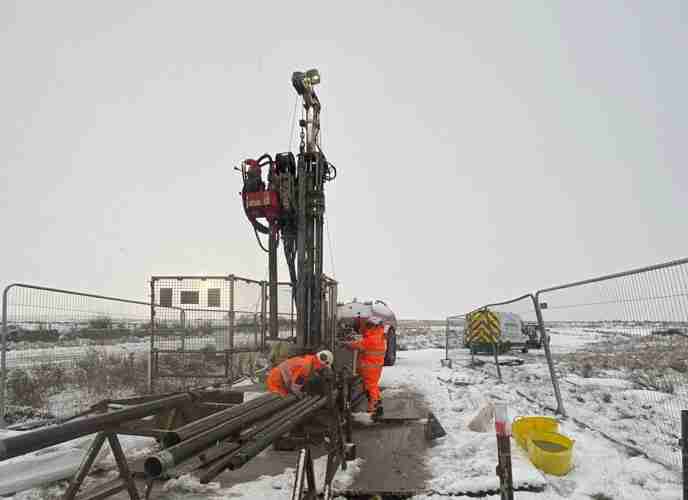
Two window sample positions were completed using a Premier Compact Modular rig due to the identification of water voles following an ecological survey and the subsequent need to prevent disturbance to their burrows. This type of rig is a highly specialised tool for ground drilling and soil sampling. Its modular and lightweight design, with no component exceeding 65 kg, ensures easy portability where access to tracked machinery is limited. This makes it especially suitable for confined spaces such as the embankment, where its parts can be carried individually.
The remaining 3 positions were drilled using a Terrier 2000 rig. These positions were located in areas with no risk to ecological disturbance. As an extra precaution to protect the ecology around BH01, ground protection boards were used in a leapfrog pattern so that the Terrier rig did not track directly on the ground when manoeuvring to position. BH04 and BH05 were located away from the canal on an area of private land.
Standard Penetration Testing was undertaken throughout each borehole. Four of the window sample positions
contained material so soft that self-weight penetration occurred. This is the process in which penetration occurs due to the gravitational force acting on the testing equipment overcomes the resistance of the material it is penetrating.
Dynamic probe holes were undertaken from the base of three of the borehole positions to a maximum of 10.00mbgl. A dynamic probe is a geotechnical tool used to evaluate the resistance of soil or soft rock to dynamic penetration. The method involves driving a cone (in this case, a sacrificial cone) into the ground with a hammer of a specified mass and drop height, and recording the number of blows needed to penetrate a certain depth (usually 100mm). This technique provides a continuous profile of ground resistance with depth, identifying variations in soil density and strength.
Undisturbed ‘U’ samples were obtained throughout each borehole and extracted from the ground with minimal disturbance to its natural structure and properties. These samples are vital for accurate soil testing and analysis as they preserve the in-situ condition of the cohesive soil in which they were taken.
Various hand shear vane tests were undertaken within the cohesive material throughout each borehole. The purpose of these tests is to measure the undrained shear strength of any cohesive soils.
CEMAR (Contract Event Management and Reporting) was utilised on this project as a tool to enhance the management of the contract. This software supports project managers, contractors, and their teams by advancing collaboration, ensuring adherence to regulations, mitigating risks, and simplifying contract administration processes.
All required precautions were consistently upheld throughout the project, enabling the works to be carried out safely, efficiently, and in full compliance with environmental protocols. This disciplined approach supported responsible execution across all phases of activity.
Explore similar projects
West of Orkney Windfarm

Cropthorne STW Phase 2

Grwyne Fawr Reservoir – Dam Stability Study

The Thorpe Marsh Green Energy Hub: Battery Energy Storage System

50 Fenchurch Street Ground Investigation

Elan Valley Aqueduct – Bath Coppice Tunnels
-
Centurion House, Olympus Park
Quedgeley, Gloucester GL2 4NF - 01452 527 743
-
Jactin House, 24 Hood Street
Ancoats, Manchester, M4 6WX - 0161 327 3933
- geotech@geoeng.co.uk
- geospatial@geoeng.co.uk